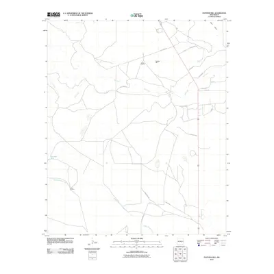
2010 Map of Panther Hill
USGS Topo · Published 2010About this map
Panther Hill rises above a high-desert landscape in Chaves County, where water management remains the central theme of land use and geography. This 2010 survey highlights a sparse network of ranching infrastructure, where named water features like Tom Ned Tank and seasonal drainage paths such as Middle Berrendo Creek and Salt Creek define the movement across the terrain. The survival of named outposts like Panther Windmill and Butler Windmill underscores the historical reliance on groundwater in this part of Eden Valley. The road network is largely functional, including industrial corridors like Pipeline Rd alongside local routes with distinctive ranching-era names like 1 Horse Rd, Knubbin Rd, and Twistflower Rd. This map captures a modern snapshot of a working landscape that still adheres to the hydrological boundaries established by early New Mexico ranchers.
Find a feature on this map
16 named features on this map. Tap any name to fly to it.
Don’t see what you’re looking for? This feature index may not catch every label — zoom into the map to look around manually.
Map Details
Editions of this 2010 Panther Hill Map
This is the sole edition of this map. No revisions or reprints were ever made.
Other maps of this area

1949 · Roswell North
USGS Topo · 1:24,000

1949 · Corn Ranch
USGS Topo · 1:24,000

1950 · Corn Ranch
USGS Topo · 1:24,000

1950 · Bitter Lake
USGS Topo · 1:24,000

1955 · Roswell
USGS Topo · 1:250,000

1958 · Roswell
USGS Topo · 1:250,000

1962 · Roswell
USGS Topo · 1:250,000
1962 · Roswell North
USGS Topo · 1:24,000

1962 · Rock House Canyon
USGS Topo · 1:24,000
1962 · Bitter Lake
USGS Topo · 1:24,000