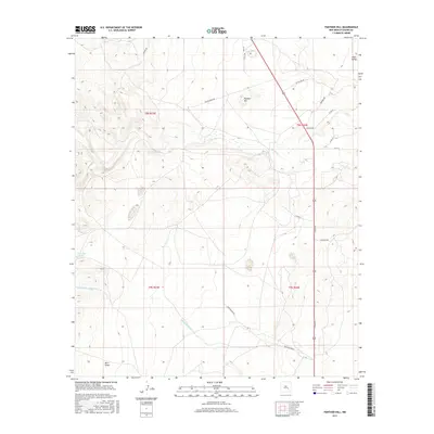
2017 Map of Panther Hill
USGS Topo · Published 2017About this map
Panther Hill rises as a prominent landmark in this section of Chaves County, anchoring a high desert landscape defined by ephemeral watercourses and a modernizing road network. The drainage patterns of Salt Creek and Middle Berrendo Cr cut through the terrain, while stock features like Tom Ned Tank indicate the ongoing importance of water management in the arid Chaves County basin. The area's development is traced through a grid of rural routes with evocative names such as Snap Dragon Rd, Twistflower Rd, and Verbeno Rd, which intersect with the major regional artery of Highway 285. This 2017 survey illustrates the intersection of traditional land use and contemporary infrastructure near the Pecos River valley, capturing the precise layout of local access roads and township boundaries as they existed in the early 21st century.
Find a feature on this map
26 named features on this map. Tap any name to fly to it.
Don’t see what you’re looking for? This feature index may not catch every label — zoom into the map to look around manually.
Map Details
Editions of this 2017 Panther Hill Map
This is the sole edition of this map. No revisions or reprints were ever made.
Other maps of this area

1949 · Roswell North
USGS Topo · 1:24,000

1949 · Corn Ranch
USGS Topo · 1:24,000

1950 · Corn Ranch
USGS Topo · 1:24,000

1950 · Bitter Lake
USGS Topo · 1:24,000

1955 · Roswell
USGS Topo · 1:250,000

1958 · Roswell
USGS Topo · 1:250,000

1962 · Roswell
USGS Topo · 1:250,000
1962 · Roswell North
USGS Topo · 1:24,000

1962 · Rock House Canyon
USGS Topo · 1:24,000
1962 · Bitter Lake
USGS Topo · 1:24,000