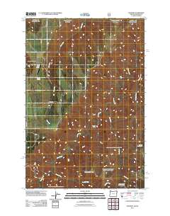
2011 Map of Paradise
USGS Topo · Published 2011About this map
Paradise and its surrounding ranchlands sit at the intersection of steep drainage systems and high ridges along the border of Washington and Oregon. This high-plateau landscape is defined by the winding course of Joseph Creek and the deep cut of Applegate Canyon, where the elevation shifts between wide grazing areas like Soap Flat and prominent heights such as Horse Pasture Ridge. The settlement of Paradise remains the primary hub of the area, connected by Paradise Rd and Kuhn Rd to outlying landmarks. Genealogists and local historians can locate the Paradise Cemetery north of the main settlement, while the Beach Ranch Airstrip serves as a remote aviation point. The network of seasonal water sources, including Tamarack Creek Spring and the drainage of Rush Creek, illustrates the essential water management required for land use in this arid, dissected terrain.
Find a feature on this map
18 named features on this map. Tap any name to fly to it.
Don’t see what you’re looking for? This feature index may not catch every label — zoom into the map to look around manually.
Map Details
Editions of this 2011 Paradise Map
This is the sole edition of this map. No revisions or reprints were ever made.
Other maps of this area

1943 · Saddle Butte
USGS Topo · 1:62,500

1944 · Anatone
USGS Topo · 1:62,500

1946 · Saddle Butte
USGS Topo · 1:62,500

1946 · Anatone
USGS Topo · 1:62,500

1955 · Pullman
USGS Topo · 1:250,000

1955 · Grangeville
USGS Topo · 1:250,000

1958 · Pullman
USGS Topo · 1:250,000

1959 · Grangeville
USGS Topo · 1:250,000
1967 · Table Mountain
USGS Topo · 1:24,000
1967 · Billy Meadows
USGS Topo · 1:24,000