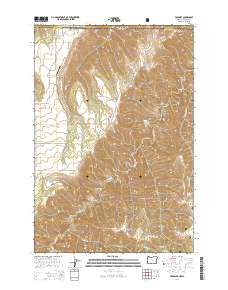
2014 Map of Paradise
USGS Topo · Published 2014About this map
The high plateau and canyon country where Washington and Oregon meet is defined by the rural settlement of Paradise and its high-elevation topography. Situated in Asotin County, Washington, and Wallowa County, Oregon, this area is characterized by dramatic elevation shifts from the drainages of Joseph Cr and Deer Cr up to the heights of Rye Ridge and Horse Pasture Ridge. The map documents the localized transportation network, centered on Paradise Rd and the Beach Ranch Airport, serving as a vital link for the high-country ranches and the Wallowa National Forest. Local history is anchored by the Paradise Cem, while the landscape is punctuated by numerous seasonal water sources and landmarks like Soap Flat, Deep Canyon, and Tamarack Creek Spring. The alignment of Josiah Cr and Peavine Cr through Brushy Gulch illustrates the complex drainage patterns that have shaped land use and ranching boundaries in this border region.
Find a feature on this map
25 named features on this map. Tap any name to fly to it.
Don’t see what you’re looking for? This feature index may not catch every label — zoom into the map to look around manually.
Map Details
Editions of this 2014 Paradise Map
This is the sole edition of this map. No revisions or reprints were ever made.
Other maps of this area

1943 · Saddle Butte
USGS Topo · 1:62,500

1944 · Anatone
USGS Topo · 1:62,500

1946 · Saddle Butte
USGS Topo · 1:62,500

1946 · Anatone
USGS Topo · 1:62,500

1955 · Pullman
USGS Topo · 1:250,000

1955 · Grangeville
USGS Topo · 1:250,000

1958 · Pullman
USGS Topo · 1:250,000

1959 · Grangeville
USGS Topo · 1:250,000
1967 · Table Mountain
USGS Topo · 1:24,000
1967 · Billy Meadows
USGS Topo · 1:24,000