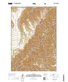
2020 Map of Paradise
USGS Topo · Published 2020About this map
Paradise sits atop a high plateau in northern Asotin County, surrounded by the steep drainages that define this corner of the Pacific Northwest. This survey captures the rural character of the region where Paradise Rd and Rye Ridge Rd provide access to remote agricultural and ranching lands. Significant local landmarks include the Beach Ranch Airport and the Paradise Cem, which serve the small upland community. To the east and south, the terrain drops dramatically into deep canyons carved by Joseph Cr and Deer Cr. The southern portion of the map transitions into the Wallowa National Forest, featuring the prominent Horse Pasture Ridge and the Horse Pasture Ridge Saddle. These landforms, alongside features like Soap Flat and Brushy Gulch, illustrate a landscape shaped by significant elevation changes and seasonal watercourses like Peavine Cr.
Find a feature on this map
27 named features on this map. Tap any name to fly to it.
Don’t see what you’re looking for? This feature index may not catch every label — zoom into the map to look around manually.
Map Details
Editions of this 2020 Paradise Map
This is the sole edition of this map. No revisions or reprints were ever made.
Other maps of this area

1943 · Saddle Butte
USGS Topo · 1:62,500

1944 · Anatone
USGS Topo · 1:62,500

1946 · Saddle Butte
USGS Topo · 1:62,500

1946 · Anatone
USGS Topo · 1:62,500

1955 · Pullman
USGS Topo · 1:250,000

1955 · Grangeville
USGS Topo · 1:250,000

1958 · Pullman
USGS Topo · 1:250,000

1959 · Grangeville
USGS Topo · 1:250,000
1967 · Table Mountain
USGS Topo · 1:24,000
1967 · Billy Meadows
USGS Topo · 1:24,000