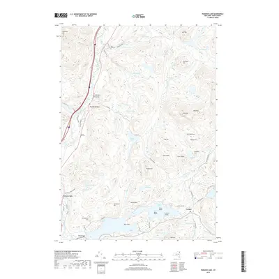
2019 Map of Paradox Lake
USGS Topo · Published 2019About this map
Paradox Lake dominates the southern landscape of this Essex County region, its irregular shoreline defined by Dark Bay, Smith Bay, and Grosvenor Bay. To the north, the Schroon River winds through the valley past the community of North Hudson and the site of Schroon Falls, marking a primary corridor through the high terrain of the Adirondacks. The map reveals a high concentration of small, high-elevation water bodies like Berrymill Pond, Hatch Pond, and Gero Pond, illustrating the complex glacial drainage of the area. Local history is anchored by several burial grounds including Ridge Cem and the Holy Name of Jesus and Mary Cemetery. The network of backroads, such as Old Furnace Rd and Stoney Lonesome Road, hints at early industrial and timber routes that once supported the small settlements of Paradox and Severance.
Find a feature on this map
75 named features on this map. Tap any name to fly to it.
Don’t see what you’re looking for? This feature index may not catch every label — zoom into the map to look around manually.
Map Details
Editions of this 2019 Paradox Lake Map
This is the sole edition of this map. No revisions or reprints were ever made.
Other maps of this area

1894 · Elizabethtown
USGS Topo · 1:62,500

1895 · Elizabethtown
USGS Topo · 1:62,500

1895 · Mt. Marcy
USGS Topo · 1:62,500

1895 · Paradox Lake
USGS Topo · 1:62,500

1897 · Paradox Lake
USGS Topo · 1:62,500

1897 · Schroon Lake
USGS Topo · 1:62,500

1901 · Elizabethtown
USGS Topo · 1:62,500

1902 · Mt. Marcy
USGS Topo · 1:62,500

1950 · Glens Falls
USGS Topo · 1:250,000

1950 · Lake Champlain
USGS Topo · 1:250,000