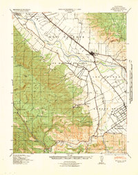
1956 Map of Paraiso Springs
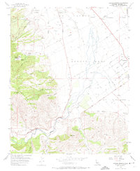
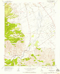
USGS Topo · Published 1974About this map
The Paraiso Springs resort and the historic lands of the Ex Mission Soledad define this landscape on the western edge of the Salinas Valley during the mid-1950s. The map illustrates the sharp transition from the irrigated orchards and vineyards of the valley floor, where the Vineyard of Mission Soledad is located, to the steep canyons of the Sierra de Salinas. Settlements like Greenfield and the smaller Mission community are positioned near the braided channels of the Arroyo Seco, showing the agricultural grid of streets such as Cherry Avenue and Walnut Avenue.
Find a feature on this map
44 named features on this map. Tap any name to fly to it.
Don’t see what you’re looking for? This feature index may not catch every label — zoom into the map to look around manually.
Map Details
Editions of this 1956 Paraiso Springs Map
3 editions found

Other maps of this area

1910 · Soledad
USGS Topo · 1:31,680

1912 · Metz
USGS Topo · 1:31,680

1915 · Soledad
USGS Topo · 1:62,500

1919 · King City
USGS Topo · 1:62,500

1919 · Junipero Serra
USGS Topo · 1:62,500

1921 · Metz
USGS Topo · 1:62,500

1939 · King City
USGS Topo · 1:62,500

1940 · Metz
USGS Topo · 1:62,500
1940 · Soledad
USGS Topo · 1:62,500

1941 · Junipero Serra
USGS Topo · 1:62,500