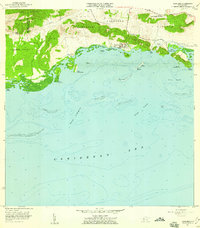
1957 Map of Parguera
USGS Topo · Published 1959About this map
The coastal village of Parguera serves as the focal point of this coastal survey, where the rugged topography of Sierra Bermeja meets the complex reef systems of the Caribbean Sea. The shoreline is defined by several ecologically distinct bays, including the world-famous Bahía Fosforescente and Bahía Montalva. Inland, the landscape transitions from the salt flats of Salinas and Salinas El Papayo to the agricultural heights of Palmarejo and Cerro Vertero.
Find a feature on this map
43 named features on this map. Tap any name to fly to it.
Don’t see what you’re looking for? This feature index may not catch every label — zoom into the map to look around manually.
Map Details
Editions of this 1957 Parguera Map
This is the sole edition of this map. No revisions or reprints were ever made.
Other maps of this area

1935 · Puerto Real
USGS Topo · 1:25,000

1937 · San German
USGS Topo · 1:25,000

1937 · Sabana Grande
USGS Topo · 1:25,000

1937 · Puerto Real
USGS Topo · 1:25,000

1938 · Guanica
USGS Topo · 1:30,000

1938 · Parguera
USGS Topo · 1:30,000

1938 · Cabo Rojo
USGS Topo · 1:30,000

1941 · San German
USGS Topo · 1:30,000

1941 · Puerto Real
USGS Topo · 1:30,000

1941 · Sabana Grande
USGS Topo · 1:30,000