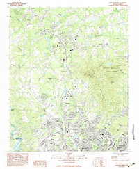
1983 Map of Paris Mountain
USGS Topo · Published 1983About this map
Furman University occupies a central position in this survey of the northern Greenville suburbs, where the Piedmont landscape begins its ascent toward Paris Mountain. The mapping reveals a transitional period of residential expansion, with established neighborhoods like Berea and Sans Souci bordering the Saluda River and Saluda Lake. Industrial and transport history is visible in the rail corridors of the Seaboard and Southern lines, which navigate the terrain alongside the Reedy River.
Find a feature on this map
78 named features on this map. Tap any name to fly to it.
Don’t see what you’re looking for? This feature index may not catch every label — zoom into the map to look around manually.
Map Details
Editions of this 1983 Paris Mountain Map
3 editions found
Other maps of this area

1888 · Pickens
USGS Topo · 1:125,000

1894 · Pickens
USGS Topo · 1:125,000

1905 · Pisgah
USGS Topo · 1:125,000

1906 · Pisgah
USGS Topo · 1:125,000

1907 · Saluda
USGS Topo · 1:125,000

1935 · Greenville
USGS Topo · 1:48,000

1938 · Greenville
USGS Topo · 1:62,500

1954 · Greenville
USGS Topo · 1:250,000

1955 · Knoxville
USGS Topo · 1:250,000

1957 · Greenville
USGS Topo · 1:24,000