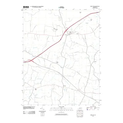
2010 Map of Park City
USGS Topo · Published 2010About this map
Park City serves as the central hub of this Barren County landscape, situated where major transportation corridors intersect near the northern edge of the sheet. The terrain is defined by a series of distinct elevations such as Bald Knob and Cox Knob, with the local drainage pattern heavily influenced by the winding courses of Little Sinking Creek and Sinking Branch. These watercourses frequently disappear into the limestone topography characteristic of the region, evidenced by features like Opossum Hollow and the notable Slave Cave Rd.
Find a feature on this map
56 named features on this map. Tap any name to fly to it.
Don’t see what you’re looking for? This feature index may not catch every label — zoom into the map to look around manually.
Map Details
Editions of this 2010 Park City Map
This is the sole edition of this map. No revisions or reprints were ever made.
Other maps of this area

1922 · Mammoth Cave
USGS Topo · 1:62,500

1923 · Mammoth Cave
USGS Topo · 1:62,500

1926 · Scottsville
USGS Topo · 1:62,500

1935 · Horse Cave
USGS Topo · 1:48,000

1938 · Horse Cave
USGS Topo · 1:62,500

1953 · Glasgow South
USGS Topo · 1:24,000

1954 · Evansville
USGS Topo · 1:250,000

1954 · Horse Cave
USGS Topo · 1:24,000
1954 · Rhoda
USGS Topo · 1:24,000
1954 · Park City
USGS Topo · 1:24,000