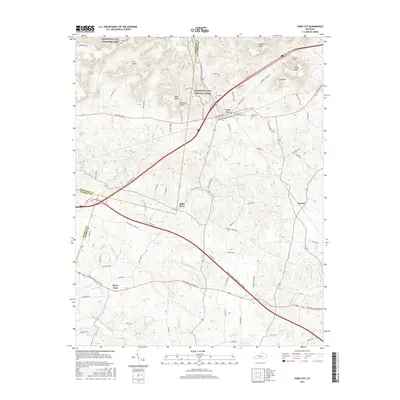
2016 Map of Park City
USGS Topo · Published 2016About this map
Mammoth Cave National Park dominates the northern landscape of this region, where the rugged topography of The Knobs meets the karst features of Barren and Edmonson counties. The hub of Park City sits at a historic crossroads, where Louisville Rd and Old Dixie Hwy intersect, serving as a gateway to the nearby cave systems. The map captures a transition from the elevated terrain of Bald Knob and Cox Knob down into the drainage basins of Little Sinking Cr and Sinking Br. Smaller rural settlements like Apple Grove, Stovall, and Merry Oaks are scattered along the local road network, often centered near family burial grounds such as Zion Cem and Evergreen Cem. This 2016 survey illustrates the modern transportation corridor where Interstate 65 and the Louie B Nunn Cumberland Pkwy bisect the agricultural and wooded landscape.
Find a feature on this map
77 named features on this map. Tap any name to fly to it.
Don’t see what you’re looking for? This feature index may not catch every label — zoom into the map to look around manually.
Map Details
Editions of this 2016 Park City Map
This is the sole edition of this map. No revisions or reprints were ever made.
Other maps of this area

1922 · Mammoth Cave
USGS Topo · 1:62,500

1923 · Mammoth Cave
USGS Topo · 1:62,500

1926 · Scottsville
USGS Topo · 1:62,500

1935 · Horse Cave
USGS Topo · 1:48,000

1938 · Horse Cave
USGS Topo · 1:62,500

1953 · Glasgow South
USGS Topo · 1:24,000

1954 · Evansville
USGS Topo · 1:250,000

1954 · Horse Cave
USGS Topo · 1:24,000
1954 · Rhoda
USGS Topo · 1:24,000
1954 · Park City
USGS Topo · 1:24,000