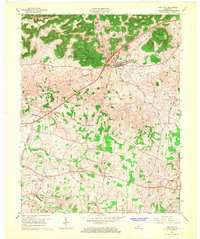
1966 Map of Park City
USGS Topo · Published 1968About this map
Diamond Caverns and Jessie James Cave highlight the subterranean character of this landscape at the southern edge of Mammoth Cave National Park. The mid-1960s terrain is defined by a karst topography of sinkholes and ridges known as The Knobs, including Bald Knob and Brushy Knob. The Louisville and Nashville railroad corridor serves as the primary artery through Park City, which appears here with its local High Sch and Evergreen Cem. Settlement patterns follow the winding routes south of the rail line, connecting smaller communities like Merry Oaks, Apple Grove, and Stovall. Rural life is centered around several modest congregations, such as Walnut Hill Ch and Cedar Hill Ch, while the drainage of Little Sinking Creek illustrates the complex hydrology of the Barren County countryside.
Find a feature on this map
36 named features on this map. Tap any name to fly to it.
Don’t see what you’re looking for? This feature index may not catch every label — zoom into the map to look around manually.
Map Details
Editions of this 1966 Park City Map
This is the sole edition of this map. No revisions or reprints were ever made.
Other maps of this area

1922 · Mammoth Cave
USGS Topo · 1:62,500

1923 · Mammoth Cave
USGS Topo · 1:62,500

1926 · Scottsville
USGS Topo · 1:62,500

1935 · Horse Cave
USGS Topo · 1:48,000

1938 · Horse Cave
USGS Topo · 1:62,500

1953 · Glasgow South
USGS Topo · 1:24,000

1954 · Evansville
USGS Topo · 1:250,000

1954 · Horse Cave
USGS Topo · 1:24,000
1954 · Rhoda
USGS Topo · 1:24,000
1954 · Park City
USGS Topo · 1:24,000