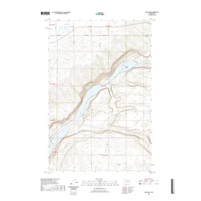
2020 Map of Park Lake
USGS Topo · Published 2020About this map
Park Lake and the elongated basin of Blue Lake dominate this portion of the Grand Coulee landscape, where the basalt cliffs and canyon floor create a series of distinct water bodies. The terrain transitions from the high plateaus of Douglas Co and Grant Co down into a deep coulee floor that contains Alkali Lake and Bluff Lake to the south. This 2020 survey illustrates a sparsely settled but recreationally significant region, featuring the Boy Scout Trail winding near Rainbow Lake and Mirror Lake. Significant geological features like Big Rock Island and High Hill provide prominent landmarks within the coulee, while the rectilinear grid of E Baseline Rd and Rd 29 NE highlights the agricultural organization of the surrounding uplands.
Find a feature on this map
24 named features on this map. Tap any name to fly to it.
Don’t see what you’re looking for? This feature index may not catch every label — zoom into the map to look around manually.
Map Details
Editions of this 2020 Park Lake Map
This is the sole edition of this map. No revisions or reprints were ever made.
Other maps of this area

1930 · Grand Coulee Sheet 3
USGS Topo · 1:31,680

1953 · Ritzville
USGS Topo · 1:250,000

1956 · Ephrata
USGS Topo · 1:62,500

1956 · Stratford
USGS Topo · 1:24,000

1956 · Soap Lake
USGS Topo · 1:24,000

1959 · Ritzville
USGS Topo · 1:250,000

1965 · Ritzville
USGS Topo · 1:250,000

1965 · Jameson Lake SE
USGS Topo · 1:24,000

1965 · St. Andrews
USGS Topo · 1:24,000

1965 · Jameson Lake East
USGS Topo · 1:24,000