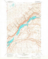
1965 Map of Park Lake
USGS Topo · Published 1967About this map
The Lower Grand Coulee corridor forms the centerpiece of this mid-1960s study, showcasing a series of deep canyon lakes that define the Channeled Scablands of Washington. Stretching from the northeastern corner toward the southwest, the chain includes Park Lake, Blue Lake, and the northern tip of Lenore Lake. These water bodies are flanked by dramatic terrain features like Jasper Canyon and Deer Canyon, illustrating the erosional power of the ancient glacial floods that carved this landscape.
Find a feature on this map
26 named features on this map. Tap any name to fly to it.
Don’t see what you’re looking for? This feature index may not catch every label — zoom into the map to look around manually.
Map Details
Editions of this 1965 Park Lake Map
This is the sole edition of this map. No revisions or reprints were ever made.
Other maps of this area

1930 · Grand Coulee Sheet 3
USGS Topo · 1:31,680

1953 · Ritzville
USGS Topo · 1:250,000

1956 · Ephrata
USGS Topo · 1:62,500

1956 · Stratford
USGS Topo · 1:24,000

1956 · Soap Lake
USGS Topo · 1:24,000

1959 · Ritzville
USGS Topo · 1:250,000

1965 · Ritzville
USGS Topo · 1:250,000

1965 · Jameson Lake SE
USGS Topo · 1:24,000

1965 · St. Andrews
USGS Topo · 1:24,000

1965 · Jameson Lake East
USGS Topo · 1:24,000