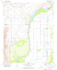
1970 Map of Parker SW
USGS Topo · Published 1977About this map
The Colorado River serves as the central artery for this borderland where California meets Arizona, defining the irrigation and transport patterns of the early 1970s. On the California side, the Riverside Mountains and Vidal Valley give way to recreation and water management at Lost Lake Resort and Lost Lake. The landscape is a stark contrast between the arid desert to the west and the highly organized agricultural grid of Parker Valley to the east. This eastern section is defined by a complex network of water infrastructure, including the Little Drain, East Drain, and a substantial Canal system supported by a Diversion Dam. Transportation follows this geographic split, with the Atchison Topeka and Santa Fe railroad and Old Parker Road navigating the western hills, while local thoroughfares like Indian School Road serve the developed valley floor and the Colorado River Day School.
Find a feature on this map
44 named features on this map. Tap any name to fly to it.
Don’t see what you’re looking for? This feature index may not catch every label — zoom into the map to look around manually.
Map Details
Editions of this 1970 Parker SW Map
3 editions found
Other maps of this area

1911 · Parker
USGS Topo · 1:125,000

1931 · Moon Mtn
USGS Topo · 1:62,500

1932 · Moon Mtn
USGS Topo · 1:62,500

1942 · Blythe
USGS Topo · 1:250,000

1942 · MOON MTN
USGS Topo · 1:62,500

1943 · Parker
USGS Topo · 1:62,500

1943 · Vidal
USGS Topo · 1:62,500

1945 · Big Maria Mtns
USGS Topo · 1:62,500

1949 · Parker
USGS Topo · 1:62,500

1949 · Vidal
USGS Topo · 1:62,500