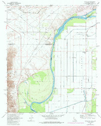
1970 Map of Parker SW
USGS Topo · Published 1986About this map
The Colorado River carves a critical boundary between California and Arizona here, defining the agricultural and recreational development of the Parker Valley. Along the western banks, the Riverside Mountains overlook a landscape marked by desert transit and extraction, featuring a Mine, Borrow Pit, and Gravel Pit. The industrial influence of the Atchison Topeka and Santa Fe railroad is evident in the north, while the river's eastern floodplain in Arizona is intensely managed for irrigation. Water control structures like the Diversion Dam and Gaging Station support the complex network of laterals and drains that feed the valley's farms. Pockets of activity such as the Colorado River Day School and Lost Lake Resort show the established community and early tourism presence near Deer Island and Twentymile Slough.
Find a feature on this map
34 named features on this map. Tap any name to fly to it.
Don’t see what you’re looking for? This feature index may not catch every label — zoom into the map to look around manually.
Map Details
Editions of this 1970 Parker SW Map
3 editions found
Other maps of this area

1911 · Parker
USGS Topo · 1:125,000

1931 · Moon Mtn
USGS Topo · 1:62,500

1932 · Moon Mtn
USGS Topo · 1:62,500

1942 · Blythe
USGS Topo · 1:250,000

1942 · MOON MTN
USGS Topo · 1:62,500

1943 · Parker
USGS Topo · 1:62,500

1943 · Vidal
USGS Topo · 1:62,500

1945 · Big Maria Mtns
USGS Topo · 1:62,500

1949 · Parker
USGS Topo · 1:62,500

1949 · Vidal
USGS Topo · 1:62,500