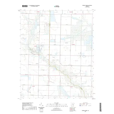
2020 Map of Parkers Corner
USGS Topo · Published 2020About this map
Parkers Corner sits at the heart of this agricultural landscape, where the flatlands of the Grand Prairie and Long Prairie meet a complex network of waterways. The terrain is defined by its drainage and irrigation patterns, essential for the local rice and soybean economy. Distinctive water features such as Bayou Two Prairie, South Branch LaGrue Bayou, and Gum Swamp meander through the prairie, while man-made improvements like Joe Uhiren Reservoir and Blue Point Ditch highlight the intensive land management of the region. Local history is anchored by the Zion Cem and Lutheran Cem, which serve as quiet markers of the community's ancestral roots. A grid of county roads, including Otis Parker Rd and Elton Parker Rd, connects the scattered farmsteads and rural homesites that characterize this portion of Lonoke and Prairie counties.
Find a feature on this map
61 named features on this map. Tap any name to fly to it.
Don’t see what you’re looking for? This feature index may not catch every label — zoom into the map to look around manually.
Map Details
Editions of this 2020 Parkers Corner Map
This is the sole edition of this map. No revisions or reprints were ever made.
Other maps of this area

1935 · Hazen
USGS Topo · 1:62,500

1937 · Stuttgart
USGS Topo · 1:62,500

1937 · England
USGS Topo · 1:48,000

1939 · Stuttgart
USGS Topo · 1:62,500

1940 · Lonoke
USGS Topo · 1:62,500

1941 · Hazen
USGS Topo · 1:62,500

1943 · England
USGS Topo · 1:62,500

1948 · Helena
USGS Topo · 1:250,000

1949 · Lonoke
USGS Topo · 1:62,500

1950 · Helena
USGS Topo · 1:250,000