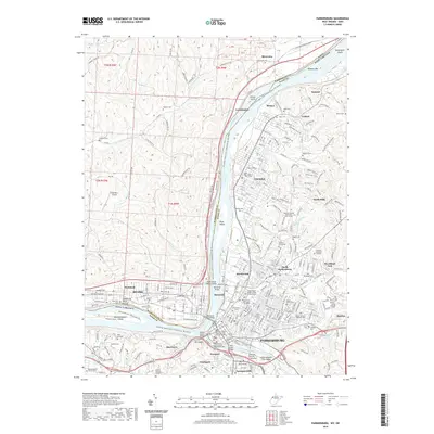
2019 Map of Parkersburg
USGS Topo · Published 2019About this map
The Ohio River dominates this landscape at the confluence with the Little Kanawha River, serving as the boundary between Washington Co and Wood Co. The West Virginia side shows the dense urban expansion of Parkersburg and Vienna, where industrial corridors along the CSX Transportation line meet residential developments in North Hills and Woodland Park. Historical land use is evident in the numerous burial grounds, such as Mount Olivet Cem and the Independent Order of Odd Fellows Cem, which sit alongside mid-century civic structures like the Parkersburg High School. Across the water in Ohio, the terrain transitions to the ridges and runs of Belpre and Rockland. Notable river features include the elongated Blennerhassett Island and its landmark Blennerhassett Bluff, while modern infrastructure is represented by the Memorial Bridge and the winding Blennerhassett Island Loop Trail.
Find a feature on this map
215 named features on this map. Tap any name to fly to it.
Don’t see what you’re looking for? This feature index may not catch every label — zoom into the map to look around manually.
Map Details
Editions of this 2019 Parkersburg Map
This is the sole edition of this map. No revisions or reprints were ever made.
Other maps of this area

1902 · Parkersburg
USGS Topo · 1:62,500

1904 · Parkersburg
USGS Topo · 1:62,500

1904 · Marietta
USGS Topo · 1:62,500

1906 · Elizabeth
USGS Topo · 1:62,500

1906 · Belleville
USGS Topo · 1:62,500

1924 · Belleville
USGS Topo · 1:62,500

1924 · Marietta
USGS Topo · 1:62,500

1924 · Elizabeth
USGS Topo · 1:62,500

1926 · Elizabeth
USGS Topo · 1:62,500

1926 · Belleville
USGS Topo · 1:62,500