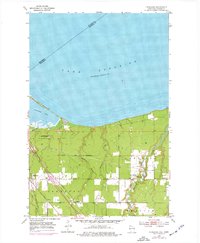
1954 Map of Parkland
USGS Topo · Published 1976About this map
Wisconsin Point stretches across the mouth of Allouez Bay in this mid-century survey of the Douglas County coastline. The landscape is defined by the heavy rail infrastructure of the Burlington Northern and Chicago and Northwestern lines, which cut through the settlement of Parkland toward the industrial waterfront. To the east, the Amnicon River meanders toward Lake Superior, passing near the Millview Community Club. The map captures a moment when rural residential clusters and small-scale infrastructure, such as a Landing Strip and a Gravel Pit, were interspersed between the creeks feeding the lake. The Superior City Boundary marks the western edge of the quadrangle, illustrating the transition from the city's outskirts to more open drainage basins like Dutchman Creek and Morrison Creek.
Find a feature on this map
19 named features on this map. Tap any name to fly to it.
Don’t see what you’re looking for? This feature index may not catch every label — zoom into the map to look around manually.
Map Details
Editions of this 1954 Parkland Map
3 editions found
Other maps of this area

1895 · Duluth
USGS Topo · 1:62,500

1915 · Superior
USGS Topo · 1:48,000

1917 · Superior
USGS Topo · 1:62,500

1949 · Poplar
USGS Topo · 1:48,000

1953 · Lakewood
USGS Topo · 1:24,000

1953 · Duluth
USGS Topo · 1:24,000

1953 · Duluth
USGS Topo · 1:62,500

1953 · Ashland
USGS Topo · 1:250,000

1953 · Duluth
USGS Topo · 1:250,000

1954 · Sunnyside
USGS Topo · 1:24,000