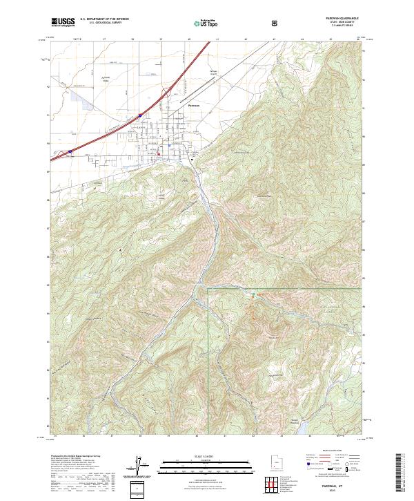
2023 Map of Parowan
USGS Topo · Published 2023About this map
Parowan sits at the foot of the Hurricane Cliffs, where the arid floor of the Parowan Valley meets the high, complex drainages of the Dixie National Forest. This modern record reveals a landscape defined by water management and steep elevation shifts, with The Forebay and Parowan Creek providing critical infrastructure for the settlement below. To the east, the terrain rises sharply toward landmarks like Valentine Peak and the geological formation of Noahs Ark. The map captures the interface of town and wildland, showing the organized grid of Parowan streets leading directly into the rugged Parowan Canyon. South of town, First Mound and Grass Valley mark the lower transitions, while high-altitude features like Yankee Meadows and Dry Lakes Creek illustrate the water sources that sustain this high-desert community. Local history is anchored at the Parowan City Cem and the Parowan Airport, reflecting the community's long-standing presence in this corner of Iron County.
Find a feature on this map
70 named features on this map. Tap any name to fly to it.
Don’t see what you’re looking for? This feature index may not catch every label — zoom into the map to look around manually.
Map Details
Editions of this 2023 Parowan Map
This is the sole edition of this map. No revisions or reprints were ever made.
Other maps of this area

1886 · Kanab
USGS Topo · 1:250,000

1953 · Cedar City
USGS Topo · 1:250,000

1958 · Cedar City
USGS Topo · 1:250,000

1958 · Cedar Breaks
USGS Topo · 1:62,500

1958 · Panguitch Lake
USGS Topo · 1:62,500

1962 · Cedar City
USGS Topo · 1:250,000

1971 · Paragonah
USGS Topo · 1:24,000
1971 · Summit
USGS Topo · 1:24,000
1971 · Cottonwood Mtn
USGS Topo · 1:24,000

1971 · Parowan
USGS Topo · 1:24,000