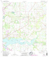
1973 Map of Parrish
USGS Topo · Published 1987About this map
Parrish serves as the focal point of this inland Manatee County landscape, situated where the Seaboard Coast Line railroad intersects a network of agricultural roads and drainage projects. The map illustrates a transitional period of land use, where traditional citrus groves and hamlets meet expanding recreational and residential interests. Along the Manatee River, the terrain shifts from the low-lying Tidal Flat and Marsh Island to established sites like the Christian Retreat Campground and a public Boat Ramp at the end of Fort Hamer Road. Genealogy and local history are anchored by the Fortner Cem and several country churches, including St Marys Ch and Mill Creek Ch. The influence of water management is evident in the straight lines of the Buffalo Canal and Frye Canal, which contrast with the meandering course of Gamble Creek and the natural wetlands of Big Sawgrass and Cabbage Slough.
Find a feature on this map
36 named features on this map. Tap any name to fly to it.
Don’t see what you’re looking for? This feature index may not catch every label — zoom into the map to look around manually.
Map Details
Editions of this 1973 Parrish Map
3 editions found
Other maps of this area

1921 · Fort De Soto
USGS Topo · 1:62,500

1942 · Cockroach Bay
USGS Topo · 1:31,680

1944 · Ruskin
USGS Topo · 1:31,680

1944 · Rye
USGS Topo · 1:31,680

1944 · Wimauma
USGS Topo · 1:31,680

1944 · Verna
USGS Topo · 1:31,680

1944 · Lorraine
USGS Topo · 1:31,680

1944 · Ellenton
USGS Topo · 1:31,680

1944 · Parish
USGS Topo · 1:31,680

1945 · Cockroach Bay
USGS Topo · 1:31,680