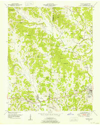
1950 Map of Parsons
USGS Topo · Published 1953About this map
Parsons serves as the primary hub of this 1950s landscape, positioned near the eastern edge where it meets the Henderson and Decatur County line. The area's transit history is visible through the Dismantled Railroad corridor running east-west through Darden and Beacon, contrasting with the preserved natural boundary of the Natchez Trace State Park and Forest in the northwest. Numerous small communities and family-named points like Bible Hill and New Safford are scattered throughout the winding creeks and hollows.
Find a feature on this map
96 named features on this map. Tap any name to fly to it.
Don’t see what you’re looking for? This feature index may not catch every label — zoom into the map to look around manually.
Map Details
Editions of this 1950 Parsons Map
2 editions found
Other maps of this area

1936 · Yuma
USGS Topo · 1:24,000

1936 · Scotts Hill
USGS Topo · 1:24,000

1936 · Parsons
USGS Topo · 1:24,000

1936 · Jeannette
USGS Topo · 1:24,000

1936 · Reagan
USGS Topo · 1:24,000

1936 · Sugar Tree
USGS Topo · 1:24,000

1936 · Cavvia
USGS Topo · 1:24,000

1936 · Perryville
USGS Topo · 1:24,000

1936 · Chesterfield
USGS Topo · 1:24,000

1949 · Perryville
USGS Topo · 1:24,000