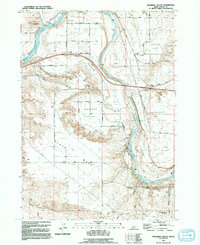
1992 Map of Pasadena Valley
USGS Topo · Published 1992About this map
The Snake River carves a deep path through this portion of Elmore County, defining a landscape where irrigation infrastructure and pioneer history converge. Water management is central to the area's development, evidenced by the Gopher Canal, King Hill Lateral, and several siphons and pumping stations that serve the agricultural lands of Pasadena Valley. Along the southern heights of Black Mesa, the historic route of the Oregon Trail remains visible, tracing a path above Rosevear Gulch. Local history is anchored by the Pilgrim Stage Station Historic Site near Pilgrim Gulch, marking a significant point of transit from an earlier era. The map also details several natural water sources such as Pancroft Springs and Pilgrim Spring, which likely dictated the placement of early settlements and travel routes through this arid terrain.
Find a feature on this map
40 named features on this map. Tap any name to fly to it.
Don’t see what you’re looking for? This feature index may not catch every label — zoom into the map to look around manually.
Map Details
Editions of this 1992 Pasadena Valley Map
This is the sole edition of this map. No revisions or reprints were ever made.
Other maps of this area

1892 · Camas Prairie
USGS Topo · 1:125,000

1893 · Camas Prairie
USGS Topo · 1:125,000

1947 · Glenns Ferry
USGS Topo · 1:24,000

1947 · Pasadena Valley
USGS Topo · 1:24,000

1948 · Pasadena Valley
USGS Topo · 1:24,000

1948 · Glenns Ferry
USGS Topo · 1:24,000

1948 · Twentymile Butte
USGS Topo · 1:24,000

1948 · Glenns Ferry
USGS Topo · 1:62,500

1948 · Ticeska
USGS Topo · 1:24,000

1948 · Grindstone Butte
USGS Topo · 1:24,000