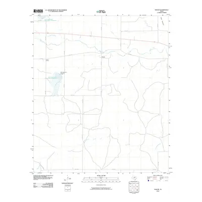
2010 Map of Pasche
USGS Topo · Published 2010About this map
Sudduth Cemetery sits near the junction of Co RD 3053 and Co RD 3034 in this rural Concho County landscape, representing a quiet corner of the Edwards Plateau. The small settlement of Pasche is centered at the intersection of Co RD 3071 and Co RD 3034, situated just south of where Brady Creek winds across the northern half of the quadrangle. This area is characterized by its organized water management and cattle-ranching infrastructure, featuring numerous man-made structures such as the Soil Conservation Service Site 21 Dam and its associated Soil Conservation Service Site 21 Reservoir. The terrain transitions into the northern highlands at the Brady Mountains, while the drainage network is defined by Maverick Creek and the meandering South Brady Creek. The prevalence of county roads and conservation reservoirs indicates a landscape focused on resource management and rural transit at the start of the 21st century.
Find a feature on this map
24 named features on this map. Tap any name to fly to it.
Don’t see what you’re looking for? This feature index may not catch every label — zoom into the map to look around manually.
Map Details
Editions of this 2010 Pasche Map
This is the sole edition of this map. No revisions or reprints were ever made.
Other maps of this area

1892 · Eden
USGS Topo · 1:125,000

1896 · Eden
USGS Topo · 1:125,000

1931 · Stacy
USGS Topo · 1:62,500

1954 · Brownwood
USGS Topo · 1:250,000

1960 · Melvin
USGS Topo · 1:24,000

1967 · Millersview SE
USGS Topo · 1:24,000
1967 · Salt Gap
USGS Topo · 1:24,000
1967 · Doole SW
USGS Topo · 1:24,000

1970 · Callan
USGS Topo · 1:24,000
1970 · Needle Creek
USGS Topo · 1:24,000