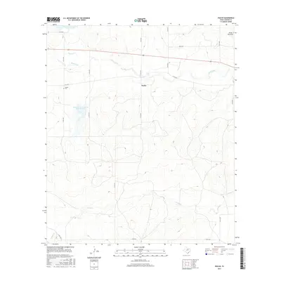
2016 Map of Pasche
USGS Topo · Published 2016About this map
Brady Creek and S Brady Cr define the hydrological landscape of this Concho County quadrangle, where the terrain shifts toward the Brady Mountains in the northeast. The small settlement of Pasche sits near the center of the sheet, served by a network of county roads such as Co RD 3071 and the prominent east-west corridor of Highway 87. Evidence of regional water management is clear through several installations, including Soil Conservation Service Site 38 Reservoir and Soil Conservation Service Site 21 Reservoir. For those tracing local family history, the Sudduth Cem is a primary landmark located near the intersection of Co RD 3053 and Co RD 3034. The map illustrates a rural landscape where drainage patterns like Maverick Cr dictate the layout of ranch roads and property boundaries.
Find a feature on this map
23 named features on this map. Tap any name to fly to it.
Don’t see what you’re looking for? This feature index may not catch every label — zoom into the map to look around manually.
Map Details
Editions of this 2016 Pasche Map
This is the sole edition of this map. No revisions or reprints were ever made.
Other maps of this area

1892 · Eden
USGS Topo · 1:125,000

1896 · Eden
USGS Topo · 1:125,000

1931 · Stacy
USGS Topo · 1:62,500

1954 · Brownwood
USGS Topo · 1:250,000

1960 · Melvin
USGS Topo · 1:24,000

1967 · Millersview SE
USGS Topo · 1:24,000
1967 · Salt Gap
USGS Topo · 1:24,000
1967 · Doole SW
USGS Topo · 1:24,000

1970 · Callan
USGS Topo · 1:24,000
1970 · Needle Creek
USGS Topo · 1:24,000