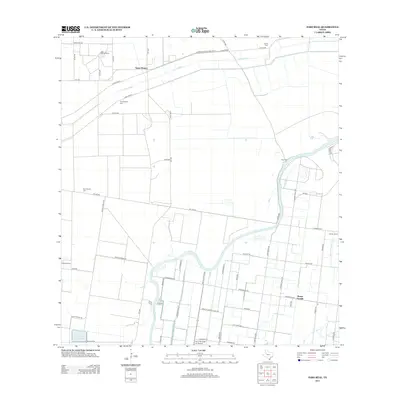
2013 Map of Paso Real
USGS Topo · Published 2013About this map
Santa Monica and the surrounding coastal plains of Willacy County are defined by an intricate network of irrigation and drainage infrastructure designed to manage the South Texas landscape. The Arroyo-Colorado meanders through the southern half of the quadrangle, flanked by a complex system of levees, including Levee Road 1 and Levee Road 2, and engineered waterways like the Pilot Channel and San Vicente Drainage Ditch. This 2013 survey illustrates the agricultural character of the region, where large landholdings such as Hardin Ranch and Totman Ranch are intersected by a grid of farm-to-market roads.
Find a feature on this map
61 named features on this map. Tap any name to fly to it.
Don’t see what you’re looking for? This feature index may not catch every label — zoom into the map to look around manually.
Map Details
Editions of this 2013 Paso Real Map
This is the sole edition of this map. No revisions or reprints were ever made.
Other maps of this area

1929 · Rio Hondo
USGS Topo · 1:24,000

1929 · Harlingen
USGS Topo · 1:24,000

1930 · La Leona
USGS Topo · 1:24,000

1930 · Laguna Atascosa
USGS Topo · 1:24,000

1932 · Combes
USGS Topo · 1:31,680

1932 · Rio Hondo
USGS Topo · 1:31,680

1932 · Harlingen
USGS Topo · 1:31,680

1933 · Paso Real
USGS Topo · 1:31,680

1936 · La Leona
USGS Topo · 1:31,680
1936 · Laguna Atascosa
USGS Topo · 1:31,680