1932 Map of Combes
USGS Topo · Published 1932About this map
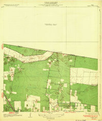
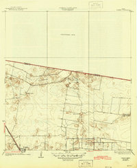
The settlement of Combes anchors the southern edge of this 1929 survey, located along the Missouri Pacific No 96 railroad line in Cameron County. The landscape is defined by the massive engineering of the North Floodway, which cuts across the terrain to manage the flow of the Rio Grande during flood stages. This industrial infrastructure contrasts with the surrounding agricultural land, which is dotted with traditional family-named ranchos such as La Puerta Ranch, La Chatonas Ranch, and El Garza Ranch. Local community life is evidenced by the Briggs Coleman Sch and a small Cem located near the town center. The presence of Briggs Road and the irrigation network suggests an area in transition toward more organized commercial farming at the edge of an unsurveyed territory near the Willacy Co Cameron Co boundary.
Find a feature on this map
13 named features on this map. Tap any name to fly to it.
Don’t see what you’re looking for? This feature index may not catch every label — zoom into the map to look around manually.
Map Details
Editions of this 1932 Combes Map
2 editions found
Historical Maps of Harlingen Through Time
1 maps found