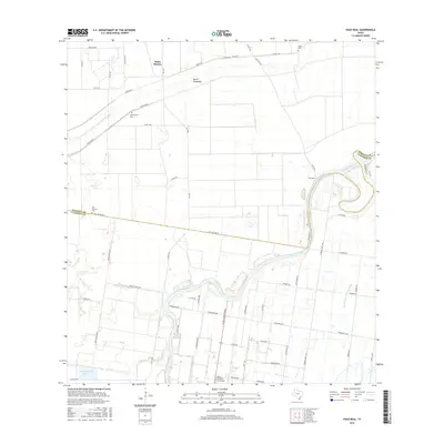
2016 Map of Paso Real
USGS Topo · Published 2016About this map
The Arroyo Colorado serpentines through the coastal prairie of South Texas, defining the landscape where Willacy Co and Cameron Co meet. This 2016 survey highlights a region shaped by complex water management, featuring the North Floodway, Pilot Channel, and the San Vicente Drainage Ditch. These engineered waterways cut through a rural environment dominated by agricultural tracts and irrigation networks essential to the Lower Rio Grande Valley's economy.
Find a feature on this map
56 named features on this map. Tap any name to fly to it.
Don’t see what you’re looking for? This feature index may not catch every label — zoom into the map to look around manually.
Map Details
Editions of this 2016 Paso Real Map
This is the sole edition of this map. No revisions or reprints were ever made.
Other maps of this area

1929 · Rio Hondo
USGS Topo · 1:24,000

1929 · Harlingen
USGS Topo · 1:24,000

1930 · La Leona
USGS Topo · 1:24,000

1930 · Laguna Atascosa
USGS Topo · 1:24,000

1932 · Combes
USGS Topo · 1:31,680

1932 · Rio Hondo
USGS Topo · 1:31,680

1932 · Harlingen
USGS Topo · 1:31,680

1933 · Paso Real
USGS Topo · 1:31,680

1936 · La Leona
USGS Topo · 1:31,680
1936 · Laguna Atascosa
USGS Topo · 1:31,680