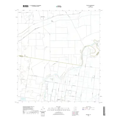
2019 Map of Paso Real
USGS Topo · Published 2019About this map
The winding Arroyo Colorado dictates the landscape of this coastal Texas region, serving as a prominent natural boundary and water source. Near its banks, the settlement of Paso Real sits alongside intricate drainage systems like the San Vicente Drainage Ditch and the Bilot Channel, reflecting the region's managed agricultural hydrology. The North Floodway cuts across the northern portion of the map, illustrating the critical infrastructure used to redirect seasonal waters near Santa Monica. For genealogists, the map identifies several local burial sites, including San Antonio Cem on the boundary between Willacy and Cameron counties, as well as Sabino Cem and Tanquesitos Cem. Aviation history is noted by the Farm Services Inc Airport, while the legacy of ranching is preserved through labels like Searcy Ranch Rd and Hardin Ranch Rd.
Find a feature on this map
58 named features on this map. Tap any name to fly to it.
Don’t see what you’re looking for? This feature index may not catch every label — zoom into the map to look around manually.
Map Details
Editions of this 2019 Paso Real Map
This is the sole edition of this map. No revisions or reprints were ever made.
Other maps of this area

1929 · Rio Hondo
USGS Topo · 1:24,000

1929 · Harlingen
USGS Topo · 1:24,000

1930 · La Leona
USGS Topo · 1:24,000

1930 · Laguna Atascosa
USGS Topo · 1:24,000

1932 · Combes
USGS Topo · 1:31,680

1932 · Rio Hondo
USGS Topo · 1:31,680

1932 · Harlingen
USGS Topo · 1:31,680

1933 · Paso Real
USGS Topo · 1:31,680

1936 · La Leona
USGS Topo · 1:31,680
1936 · Laguna Atascosa
USGS Topo · 1:31,680