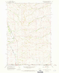
1967 Map of Pass Creek East
USGS Topo · Published 1971About this map
Aberdeen stands as a primary point of reference in this rugged borderland where Big Horn County, Montana, meets Sheridan County, Wyoming. The landscape is defined by the Crow Indian Reservation, whose boundary cuts through the southern portion of the map. Transport and commerce in the late 1960s are dominated by the Chicago Burlington and Quincy railroad, which follows the natural corridor carved by Pass Creek.
Find a feature on this map
17 named features on this map. Tap any name to fly to it.
Don’t see what you’re looking for? This feature index may not catch every label — zoom into the map to look around manually.
Map Details
Editions of this 1967 Pass Creek East Map
This is the sole edition of this map. No revisions or reprints were ever made.
Other maps of this area

1894 · Rosebud
USGS Topo · 1:125,000

1895 · Dayton
USGS Topo · 1:125,000

1901 · Rosebud
USGS Topo · 1:125,000

1901 · Dayton
USGS Topo · 1:125,000

1954 · Hardin
USGS Topo · 1:250,000

1955 · Sheridan
USGS Topo · 1:250,000

1957 · Hardin
USGS Topo · 1:250,000

1958 · Hardin
USGS Topo · 1:250,000

1958 · Sheridan
USGS Topo · 1:250,000

1962 · Sheridan
USGS Topo · 1:250,000