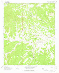
1964 Map of Pasture Canyon
USGS Topo · Published 1978About this map
Alamocita Creek carves a central path through this arid landscape, which in the mid-1960s was defined by isolated ranching outposts and a network of essential water sources. The map records several family-named locations such as the White House Ranch, McCord Place, and Box Bar Place, indicating the sparse but established settlement pattern of Catron County. The terrain is a complex system of drainage and relief, ranging from the prominent Bell Mountain in the northeast to the deeply incised Rock House Canyon. To the south, the boundary of the Cibola National Forest encompasses a series of steep drainages like Remuda Canyon and Red Canyon. This survey provides a precise record of the vital hydrologic infrastructure of the era, including naming individual points like Buds Windmill, Red Feather Well, and Alkali Tank.
Find a feature on this map
64 named features on this map. Tap any name to fly to it.
Don’t see what you’re looking for? This feature index may not catch every label — zoom into the map to look around manually.
Map Details
Editions of this 1964 Pasture Canyon Map
2 editions found
Other maps of this area

1917 · Broom Mountain
USGS Topo · 1:125,000

1954 · Socorro
USGS Topo · 1:250,000

1958 · Socorro
USGS Topo · 1:250,000

1962 · Socorro
USGS Topo · 1:250,000

1963 · Cal Ship Mesa
USGS Topo · 1:24,000

1964 · Third Canyon
USGS Topo · 1:24,000

1964 · Wiley Mesa
USGS Topo · 1:24,000

1964 · Dog Springs
USGS Topo · 1:24,000
1964 · Bonine Canyon
USGS Topo · 1:24,000

1964 · Pasture Canyon
USGS Topo · 1:24,000