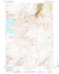
1951 Map of Pathfinder Dam
USGS Topo · Published 1983About this map
Pathfinder Dam anchors this landscape at the canyon of the North Platte River, a critical point of water management on the Natrona and Carbon County line. Built in the early 20th century, the dam created the Pathfinder Reservoir, which dominates the western and southern reaches of the map. The rugged geography surrounding the water includes the high elevations of Pathfinder Mountain and the Pedro Mountains to the south. Small-scale human infrastructure is visible near the dam site, including a Foot Bridge and a Gaging Sta. The arid basins, specifically Fremont Basin and Little Basin, are dissected by seasonal drainages such as Sand Draw and Little Canyon Creek. While largely unpopulated, the area is accessible via Kortes Road, which winds through the eastern hills, and several named water sources like Poison Spring and Suede Spring suggest the importance of local hydrology for livestock and wildlife.
Find a feature on this map
17 named features on this map. Tap any name to fly to it.
Don’t see what you’re looking for? This feature index may not catch every label — zoom into the map to look around manually.
Map Details
Editions of this 1951 Pathfinder Dam Map
3 editions found
Other maps of this area

1950 · Alcova
USGS Topo · 1:24,000

1951 · Benton Basin SW
USGS Topo · 1:24,000

1951 · Benton Basin
USGS Topo · 1:24,000

1951 · Pathfinder Reservoir NW
USGS Topo · 1:24,000

1951 · Bear Spring
USGS Topo · 1:24,000

1951 · Pathfinder Dam
USGS Topo · 1:24,000

1953 · Leo
USGS Topo · 1:24,000

1953 · Pathfinder Reservoir SW
USGS Topo · 1:24,000

1953 · Fourmile Ridge
USGS Topo · 1:24,000

1955 · Casper
USGS Topo · 1:250,000