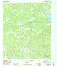
1984 Map of Patroon North
USGS Topo · Published 1985About this map
The eastern piney woods of Shelby County are defined by the Sabine National Forest and the encroaching waters of the Toledo Bend Reservoir along the eastern margin. This mid-1980s representation captures a rural landscape where small settlements like New Harmony, Chambers, and Dreka are connected by a complex network of bayous and creeks. The hydrology of the region is notably diverse, featuring numerous named drainages such as Siepe Bayou, Mushotuba Creek, and Brittain Creek that wind through the timbered terrain. Notable landmarks like the Lookout Tower and Goober Hill provide topographic points of reference amidst the dense forest cover. For local historians, the inclusion of several marked Cem locations offers valuable clues for genealogical research in this sparsely populated portion of East Texas.
Find a feature on this map
28 named features on this map. Tap any name to fly to it.
Don’t see what you’re looking for? This feature index may not catch every label — zoom into the map to look around manually.
Map Details
Editions of this 1984 Patroon North Map
This is the sole edition of this map. No revisions or reprints were ever made.
Other maps of this area

1944 · Logansport
USGS Topo · 1:62,500

1944 · Patroon
USGS Topo · 1:62,500

1953 · Alexandria
USGS Topo · 1:250,000

1953 · Palestine
USGS Topo · 1:250,000

1955 · Alexandria
USGS Topo · 1:250,000

1956 · Logansport
USGS Topo · 1:62,500

1956 · Patroon
USGS Topo · 1:62,500

1957 · Palestine
USGS Topo · 1:250,000

1958 · Center
USGS Topo · 1:62,500

1958 · San Augustine
USGS Topo · 1:62,500