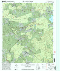
2003 Map of Patroon North
USGS Topo · Published 2004About this map
Sabine National Forest dominates this East Texas landscape, where the wooded terrain is cut by an intricate network of creeks and bayous. The 2003 revision reflects a region defined by its relationship with the Toledo Bend Reservoir, which shapes the eastern boundary and the mouth of Blue Bayou. Local history and genealogy are centered around long-standing community nodes like Patroon and Dreka, often anchored by rural congregations such as Lone Star Ch and New Harmony Ch. The map provides specific locations for early burial grounds, including Holy Spring Cem and Latham Cem, which are critical for tracing family roots in this corner of Shelby County. Small commerce centers like Jordans Store and government outposts like the Dreka Work Center (USFS) serve as landmarks within the dense timberland and along the winding courses of Mushotuba Creek and Chambers Creek.
Find a feature on this map
33 named features on this map. Tap any name to fly to it.
Don’t see what you’re looking for? This feature index may not catch every label — zoom into the map to look around manually.
Map Details
Editions of this 2003 Patroon North Map
This is the sole edition of this map. No revisions or reprints were ever made.
Other maps of this area

1944 · Logansport
USGS Topo · 1:62,500

1944 · Patroon
USGS Topo · 1:62,500

1953 · Alexandria
USGS Topo · 1:250,000

1953 · Palestine
USGS Topo · 1:250,000

1955 · Alexandria
USGS Topo · 1:250,000

1956 · Logansport
USGS Topo · 1:62,500

1956 · Patroon
USGS Topo · 1:62,500

1957 · Palestine
USGS Topo · 1:250,000

1958 · Center
USGS Topo · 1:62,500

1958 · San Augustine
USGS Topo · 1:62,500