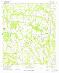
1977 Map of Patten
USGS Topo · Published 1977About this map
The agrarian landscape of Thomas County is captured here in the mid-1970s, characterized by a network of rural churches and family-named cemeteries. Settlements like Patten and Merrillville anchor the local community, while the Seaboard Coast Line railroad cuts through the northwest corner near the Thomasville Municipal Airport. The map highlights the spiritual and social foundations of the area through landmarks such as Mt Calvary Ch Cem, Kennedy Chapel Cem, and Aucilla Ch.
Find a feature on this map
43 named features on this map. Tap any name to fly to it.
Don’t see what you’re looking for? This feature index may not catch every label — zoom into the map to look around manually.
Map Details
Editions of this 1977 Patten Map
This is the sole edition of this map. No revisions or reprints were ever made.
Other maps of this area

1953 · Waycross
USGS Topo · 1:250,000

1954 · Valdosta
USGS Topo · 1:250,000

1957 · Thomasville
USGS Topo · 1:62,500

1958 · Valdosta
USGS Topo · 1:250,000

1958 · Waycross
USGS Topo · 1:250,000

1959 · Valdosta
USGS Topo · 1:250,000

1961 · Quitman
USGS Topo · 1:62,500
1975 · Thomasville
USGS Topo · 1:24,000
1975 · Merrillville
USGS Topo · 1:24,000
1977 · Chastain
USGS Topo · 1:24,000