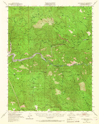
1952 Map of Patterson Mountain
USGS Topo · Published 1967About this map
Sierra National Forest lands dominate this mid-century survey, defined by the deep carving of the Kings River and its North Fork. The landscape is a working mountain environment where utility and forestry infrastructure coexist with small mountain outposts like Balch Camp and Kellers Ranch. The inclusion of the Kings River Reservoir and the Black Rock Reservoir highlights the era's focus on water management and power generation, connected by labels like Powerhouse.
Find a feature on this map
75 named features on this map. Tap any name to fly to it.
Don’t see what you’re looking for? This feature index may not catch every label — zoom into the map to look around manually.
Map Details
Editions of this 1952 Patterson Mountain Map
5 editions found

Other maps of this area

1903 · Tehipite
USGS Topo · 1:125,000

1904 · Kaiser
USGS Topo · 1:125,000

1905 · Tehipite
USGS Topo · 1:125,000

1912 · Mt. Goddard
USGS Topo · 1:125,000

1921 · Squaw Valley
USGS Topo · 1:31,680

1922 · Trimmer
USGS Topo · 1:96,000

1924 · Citrus Cove
USGS Topo · 1:31,680

1924 · Dinuba
USGS Topo · 1:125,000

1942 · Watts Valley
USGS Topo · 1:62,500

1942 · Dunlap
USGS Topo · 1:62,500