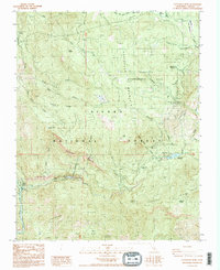
1987 Map of Patterson Mtn
USGS Topo · Published 1987About this map
Patterson Mountain and the steep river canyons of the Sierra National Forest define this high-elevation landscape in the late 1980s. The map centers on the sophisticated hydroelectric and water management systems along the Kings River, including the Haas Powerhouse and the Black Rock Reservoir. This area demonstrates a heavy investment in industrial infrastructure within a wilderness setting, evidenced by the Balch Powerhouse Substation and several Gaging Stations positioned along the tributaries. The Teakettle Experimental Area occupies the north-central portion of the quadrangle, highlighting the region's importance for forest research. Below the prominent Patterson Bluffs, the settlement of Balch Camp serves as a small human footprint amid vast natural features like Rodgers Ridge and Poison Ridge.
Find a feature on this map
46 named features on this map. Tap any name to fly to it.
Don’t see what you’re looking for? This feature index may not catch every label — zoom into the map to look around manually.
Map Details
Editions of this 1987 Patterson Mtn Map
2 editions found
Other maps of this area

1903 · Tehipite
USGS Topo · 1:125,000

1904 · Kaiser
USGS Topo · 1:125,000

1905 · Tehipite
USGS Topo · 1:125,000

1912 · Mt. Goddard
USGS Topo · 1:125,000

1922 · Trimmer
USGS Topo · 1:96,000

1924 · Dinuba
USGS Topo · 1:125,000

1947 · Mariposa
USGS Topo · 1:250,000

1948 · Fresno
USGS Topo · 1:250,000

1948 · Mariposa
USGS Topo · 1:250,000

1952 · Tehipite Dome
USGS Topo · 1:62,500