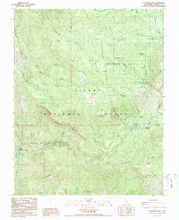
1987 Map of Patterson Mtn
USGS Topo · Published 1987About this map
The North Fork Kings River carves through the heart of the Sierra National Forest in this late 1980s topographical record. The landscape is defined by hydroelectric infrastructure and forestry research, anchored by the Balch Camp community and the nearby Balch Powerhouse and Haas Powerhouse. These facilities represent the mid-century expansion of power generation along the Sierra Nevada's steep drainages. High-elevation meadow systems like Tule Meadow and Long Meadow Creek contrast with the sheer faces of Patterson Bluffs.
Find a feature on this map
47 named features on this map. Tap any name to fly to it.
Don’t see what you’re looking for? This feature index may not catch every label — zoom into the map to look around manually.
Map Details
Editions of this 1987 Patterson Mtn Map
2 editions found
Other maps of this area

1903 · Tehipite
USGS Topo · 1:125,000

1904 · Kaiser
USGS Topo · 1:125,000

1905 · Tehipite
USGS Topo · 1:125,000

1912 · Mt. Goddard
USGS Topo · 1:125,000

1922 · Trimmer
USGS Topo · 1:96,000

1924 · Dinuba
USGS Topo · 1:125,000

1947 · Mariposa
USGS Topo · 1:250,000

1948 · Fresno
USGS Topo · 1:250,000

1948 · Mariposa
USGS Topo · 1:250,000

1952 · Tehipite Dome
USGS Topo · 1:62,500