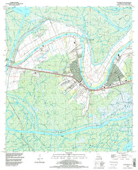
1994 Map of Patterson
USGS Topo · Published 1998About this map
Patterson and the surrounding marshlands of St Mary Parish define this landscape along the horseshoe bend of the Lower Atchafalaya River. The region’s economic reliance on water and rail is evident through the alignment of the Southern Pacific railroad and major waterways like Bayou Teche and the Intracoastal Waterway. This survey documents a complex network of bayous and canals, including Thompson Bayou and Wildcat Bayou, that support local industry and transit.
Find a feature on this map
44 named features on this map. Tap any name to fly to it.
Don’t see what you’re looking for? This feature index may not catch every label — zoom into the map to look around manually.
Map Details
Editions of this 1994 Patterson Map
This is the sole edition of this map. No revisions or reprints were ever made.
Other maps of this area

1935 · Belle Isle
USGS Topo · 1:31,680

1935 · Morgan City
USGS Topo · 1:62,500

1941 · Belle Isle
USGS Topo · 1:62,500

1945 · New Orleans
USGS Topo · 1:250,000

1948 · Foster
USGS Topo · 1:62,500
1953 · Napoleonville
USGS Topo · 1:62,500

1954 · Morgan City
USGS Topo · 1:62,500

1954 · Belle Isle
USGS Topo · 1:62,500
1959 · Foster
USGS Topo · 1:62,500

1963 · New Orleans
USGS Topo · 1:250,000