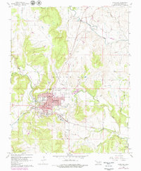
1960 Map of Pawhuska
USGS Topo · Published 1979About this map
Pawhuska serves as the focal point of this survey, shown at a time of continued petroleum development and civic expansion within the Osage Reserve. The town's layout is defined by its educational and public institutions, including the High Sch, Indian Camp Sch, and the County Fairground to the south. The landscape is heavily marked by the energy industry, with numerous Oil Wells and an extensive Oil Field spanning the hilly terrain of Strike Axe and the surrounding creek valleys.
Find a feature on this map
33 named features on this map. Tap any name to fly to it.
Don’t see what you’re looking for? This feature index may not catch every label — zoom into the map to look around manually.
Map Details
Editions of this 1960 Pawhuska Map
3 editions found
Other maps of this area

1906 · Nelagoney
USGS Topo · 1:24,000

1909 · Pawhuska
USGS Topo · 1:125,000

1910 · Pawhuska
USGS Topo · 1:125,000

1955 · Enid
USGS Topo · 1:250,000

1958 · Enid
USGS Topo · 1:250,000

1960 · Nanos
USGS Topo · 1:24,000

1960 · Nelagoney
USGS Topo · 1:24,000

1960 · Herd
USGS Topo · 1:24,000

1960 · Pawhuska
USGS Topo · 1:24,000

1964 · Barnsdall
USGS Topo · 1:24,000