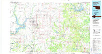
1985 Map of Pawhuska
USGS Topo · Published 1986About this map
The Osage Indian Reservation dominates this mid-1980s landscape, centered on the tribal capital at Pawhuska. The map illustrates the complex infrastructure of the region's energy and water resources, featuring the extensive Pershing Oil Field Road and numerous reservoirs like Kaw Lake and Hulah Lake. This era shows the developed state of ranching and oil country, with a dense network of secondary roads connecting scattered settlements such as Pearsonia, Boulangerville, and Gray Horse.
Find a feature on this map
68 named features on this map. Tap any name to fly to it.
Don’t see what you’re looking for? This feature index may not catch every label — zoom into the map to look around manually.
Map Details
Editions of this 1985 Pawhuska Map
2 editions found
Other maps of this area

1885 · Sedan
USGS Topo · 1:125,000

1886 · Independence
USGS Topo · 1:125,000

1889 · Burden
USGS Topo · 1:125,000

1889 · Sedan
USGS Topo · 1:125,000

1890 · Wellington
USGS Topo · 1:125,000

1894 · Independence
USGS Topo · 1:125,000

1901 · Claremore
USGS Topo · 1:125,000

1901 · Nowata
USGS Topo · 1:125,000

1905 · Independence
USGS Topo · 1:125,000

1906 · Nelagoney
USGS Topo · 1:24,000