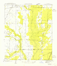
1954 Map of Pawnee
USGS Topo · Published 1954About this map
Union Hill and the surrounding piney woods of central Louisiana appear here during a period of transition for the local timber industry. The landscape is defined by the winding course of the Calcasieu River and its numerous tributaries, including Cherry Winche Creek and Masters Creek. Evidence of the region's logging heritage is prominent, with a Logging Railroad grade cutting across the northern sections and connecting with the more established Missouri Pacific Railroad near the settlement of Pawnee. Small rural centers such as Bethel serve as anchors for the community, marked by the presence of Bethel Cem. and the Union Hill Sch. The map also delineates the boundary between Rapides Parish and Allen Parish, following the meandering path of the river and local creeks. This survey provides a look at the rural infrastructure of the mid-1950s, highlighting the network of state highways like State Highway No 113 that began to replace older timber trails.
Find a feature on this map
19 named features on this map. Tap any name to fly to it.
Don’t see what you’re looking for? This feature index may not catch every label — zoom into the map to look around manually.
Map Details
Editions of this 1954 Pawnee Map
This is the sole edition of this map. No revisions or reprints were ever made.
Other maps of this area

1935 · Beaver
USGS Topo · 1:31,680

1935 · Pawnee
USGS Topo · 1:31,680

1935 · Oakdale
USGS Topo · 1:31,680

1942 · Oakdale
USGS Topo · 1:62,500

1943 · Leander
USGS Topo · 1:62,500

1947 · Steep Gully
USGS Topo · 1:31,680

1947 · Elizabeth
USGS Topo · 1:31,680

1948 · Elizabeth
USGS Topo · 1:24,000

1949 · Glenmora
USGS Topo · 1:31,680

1951 · Steep Gully
USGS Topo · 1:24,000