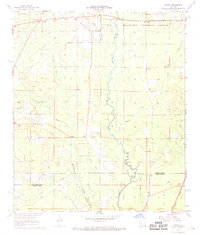
1968 Map of Pawnee
USGS Topo · Published 1969About this map
Kisatchie National Forest defines the northern reaches of this landscape, where the Calcasieu River meanders southward through a network of creeks and bayous. In the late 1960s, the area's timber and transport history is evident in the transition from an Old Railroad Grade to the active Missouri Pacific tracks near Pawnee. Small rural centers such as Union Hill and Calcasieu are centers for community life, anchored by numerous country churches including Gospel Chr and Hope Well Chr. The terrain is etched with waterways like Prairie Branch and Cherrywinche Creek, which shaped the early settlement patterns of the Rapides and Allen Parish border. Genealogists will find significant value in the detailed placement of family-named landmarks like Osburn Willis Cem and Melder Cem, providing a precise record of these piney woods communities before later 20th-century developments.
Find a feature on this map
23 named features on this map. Tap any name to fly to it.
Don’t see what you’re looking for? This feature index may not catch every label — zoom into the map to look around manually.
Map Details
Editions of this 1968 Pawnee Map
2 editions found
Other maps of this area

1935 · Beaver
USGS Topo · 1:31,680

1935 · Pawnee
USGS Topo · 1:31,680

1935 · Oakdale
USGS Topo · 1:31,680

1942 · Oakdale
USGS Topo · 1:62,500

1943 · Leander
USGS Topo · 1:62,500

1947 · Steep Gully
USGS Topo · 1:31,680

1947 · Elizabeth
USGS Topo · 1:31,680

1948 · Elizabeth
USGS Topo · 1:24,000

1949 · Glenmora
USGS Topo · 1:31,680

1951 · Steep Gully
USGS Topo · 1:24,000