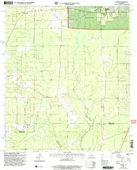
2003 Map of Pawnee
USGS Topo · Published 2005About this map
The Kisatchie National Forest dominates this Central Louisiana landscape, where the meandering Calcasieu River defines the rural character of the border between Rapides and Allen Parishes. This 2003 revision reflects a region deeply tied to forestry and small, faith-based communities, featuring a high density of country churches including Davis Crossing Ch, Bethany Ch, and Hope Well Ch. The Palustris Experimental Forest (Longleaf Tract) occupies the northeast corner, signifying the area's importance for silvicultural research. Small settlements like Union Hill and Pawnee are joined by several family-named landmarks such as the Osburn Willis Cem, providing valuable touchpoints for genealogical research. The drainage network, including Masters Creek and Cherrywinche Creek, illustrates the complex hydrology of the piney woods before they descend into the bayous of the south, such as Cow Bayou.
Find a feature on this map
23 named features on this map. Tap any name to fly to it.
Don’t see what you’re looking for? This feature index may not catch every label — zoom into the map to look around manually.
Map Details
Editions of this 2003 Pawnee Map
This is the sole edition of this map. No revisions or reprints were ever made.
Other maps of this area

1935 · Beaver
USGS Topo · 1:31,680

1935 · Pawnee
USGS Topo · 1:31,680

1935 · Oakdale
USGS Topo · 1:31,680

1942 · Oakdale
USGS Topo · 1:62,500

1943 · Leander
USGS Topo · 1:62,500

1947 · Steep Gully
USGS Topo · 1:31,680

1947 · Elizabeth
USGS Topo · 1:31,680

1948 · Elizabeth
USGS Topo · 1:24,000

1949 · Glenmora
USGS Topo · 1:31,680

1951 · Steep Gully
USGS Topo · 1:24,000