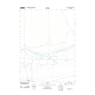
2011 Map of Paxton North
USGS Topo · Published 2011About this map
The North Platte River flows through this portion of Keith County, Nebraska, defining a landscape shaped by early 21st-century water management and agriculture. The settlement of Sarben sits centrally along the river corridor, while a corner of Paxton is visible in the southwestern section. The area's reliance on irrigation is evident through a complex network of man-made waterways, including the Sheridan Wilson Canal, the Keith Lincoln Canal, and the larger Sutherland Canal. These features illustrate the technical effort required to sustain the region's agricultural economy. Local infrastructure is further detailed with landmarks like McConnell Field and a grid of rural routes such as Keystone Sarben N Rd. Natural drainages like East Clear Creek and Cedar Creek feed into the main river valley, completing the hydraulic profile of this High Plains environment.
Find a feature on this map
14 named features on this map. Tap any name to fly to it.
Don’t see what you’re looking for? This feature index may not catch every label — zoom into the map to look around manually.
Map Details
Editions of this 2011 Paxton North Map
This is the sole edition of this map. No revisions or reprints were ever made.
Other maps of this area

1898 · Paxton
USGS Topo · 1:125,000

1901 · Paxton
USGS Topo · 1:125,000

1954 · North Platte
USGS Topo · 1:250,000

1956 · North Platte
USGS Topo · 1:250,000

1957 · North Platte
USGS Topo · 1:250,000

1967 · North Platte
USGS Topo · 1:250,000

1971 · Sutherland Reservoir West
USGS Topo · 1:24,000
1971 · Paxton South
USGS Topo · 1:24,000
1971 · Nevens
USGS Topo · 1:24,000
1971 · Paxton North
USGS Topo · 1:24,000