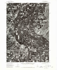
1974 Map of Payette
USGS Topo · Published 1975About this map
Payette and Ontario anchor this 1974 orthophoto quadrangle, which provides a photographic record of the Idaho-Oregon borderlands. The landscape is defined by the confluence of the Payette River and the Snake River, where the serpentine waterways carve through a grid of agricultural tracts and orchards. In the center of the sheet, the community of Fruitland sits amidst dense patterns of irrigation and field crops, illustrating the region's reliance on river-fed farming. Because this is an orthophotoquad rather than a traditional topographic map, the imagery captures the precise physical footprint of mid-1970s downtown cores, industrial rail sidings, and the evolving residential expansion into the surrounding valley. It offers a rare, overhead perspective of the twin-city relationship across the state line during a period of steady Pacific Northwest development.
Find a feature on this map
5 named features on this map. Tap any name to fly to it.
Don’t see what you’re looking for? This feature index may not catch every label — zoom into the map to look around manually.
Map Details
Editions of this 1974 Payette Map
This is the sole edition of this map. No revisions or reprints were ever made.
Other maps of this area

1897 · Weiser
USGS Topo · 1:125,000

1898 · Nampa
USGS Topo · 1:125,000

1906 · Mitchell Butte
USGS Topo · 1:125,000

1951 · Moores Hollow
USGS Topo · 1:24,000

1951 · Malheur Butte
USGS Topo · 1:24,000

1951 · Moores Hollow
USGS Topo · 1:62,500

1951 · Payette
USGS Topo · 1:24,000

1951 · Weiser South
USGS Topo · 1:24,000

1952 · Weiser Cove
USGS Topo · 1:24,000

1952 · Birding Island
USGS Topo · 1:24,000