
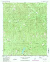
1980 Map of Payne Lake
USGS Topo · Published 1980About this map
Talladega National Forest dominates this section of the West Alabama woodlands, where the headwaters of numerous creeks converge near the Hale Co Bibb Co line. The recreational landscape centers on Payne Lake, featuring a dedicated Recreation Area, Campground, and Picnic Area. This 1980 survey captures a region defined by its timber and water resources, with an Old Railroad Grade tracing a path through the northeast corner, reflecting the area's history of logging and transport. Local life is anchored by landmarks such as Pine Flat Ch, Pisgah Cem, and the Payne Lookout Tower, which stands as a sentinel over the undulating terrain. The presence of Keeton Corner and the South Sandy Hunter Camp highlights the area's long-standing connection to outdoor pursuits and rural settlement within the forest boundaries.
Find a feature on this map
23 named features on this map. Tap any name to fly to it.
Don’t see what you’re looking for? This feature index may not catch every label — zoom into the map to look around manually.
Map Details
Editions of this 1980 Payne Lake Map
2 editions found
Other maps of this area

1899 · Brookwood
USGS Topo · 1:125,000

1924 · Tuscaloosa
USGS Topo · 1:62,500

1926 · Tuscaloosa
USGS Topo · 1:62,500

1931 · Cottondale
USGS Topo · 1:48,000

1934 · Cottondale
USGS Topo · 1:62,500

1953 · Montgomery
USGS Topo · 1:250,000

1953 · Birmingham
USGS Topo · 1:250,000

1956 · Birmingham
USGS Topo · 1:250,000

1956 · Montgomery
USGS Topo · 1:250,000

1957 · Birmingham
USGS Topo · 1:250,000