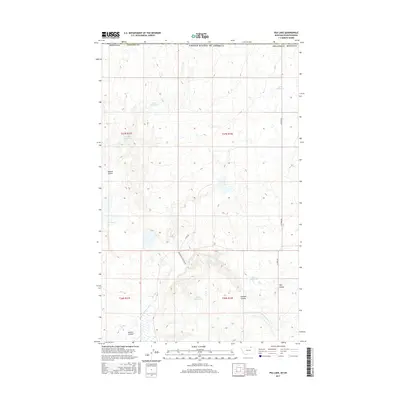
2017 Map of Pea Lake
USGS Topo · Published 2017About this map
Pea Lake and a series of livestock reservoirs dominate this arid segment of Phillips County along the international border with Canada. The landscape is defined by the drainage patterns of the E Fork Whitewater Cr, where several deep-cut coulees like Haukos Coulee and Gustin Coulee break the high plains terrain. This 2017 survey details a remote ranching environment where water management is critical, evidenced by named catchments such as Artie Reservoir, Lester Reservoir, and Ethel Reservoir. Isolated tracks including Anderson Cutacross Rd and Math Rd provide the only transit through these northern townships, following the natural contours of the land rather than a strict grid. The map captures the specialized geography of the Big Muddy Creek region, showing how human infrastructure like the Nerve Reservoir and Sarm Reservoir has been integrated into the natural coulee systems to support agricultural life in the Montana backcountry.
Find a feature on this map
22 named features on this map. Tap any name to fly to it.
Don’t see what you’re looking for? This feature index may not catch every label — zoom into the map to look around manually.
Map Details
Editions of this 2017 Pea Lake Map
This is the sole edition of this map. No revisions or reprints were ever made.
Other maps of this area

1920 · Cowan
USGS Topo · 1:125,000

1954 · Glasgow
USGS Topo · 1:250,000

1957 · Glasgow
USGS Topo · 1:250,000

1958 · Glasgow
USGS Topo · 1:250,000

1984 · Pea Lake
USGS Topo · 1:24,000

1984 · Whitewater East
USGS Topo · 1:24,000

1984 · Whitewater West
USGS Topo · 1:24,000
1984 · Thoeny Hills West
USGS Topo · 1:24,000
1984 · Gustin Coulee
USGS Topo · 1:24,000
1984 · Salsbery Reservoir
USGS Topo · 1:24,000