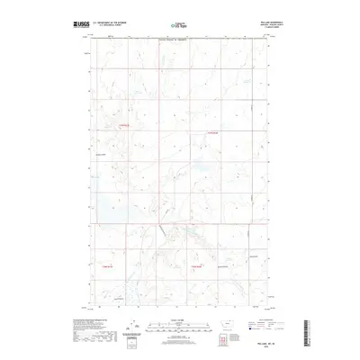
2020 Map of Pea Lake
USGS Topo · Published 2020About this map
Pea Lake and a series of livestock reservoirs dominate this Phillips County landscape, showing a region defined by water management and vast open range near the Canadian border. The terrain is marked by distinct drainage features like Haukos Coulee and Dunham Coulee, while the E Fork Whitewater Cr winds through the southern portion of the quadrangle. Significant water storage points such as Artie Reservoir, Lester Reservoir, and Sarm Reservoir suggest an active ranching economy reliant on these man-made catchments. A network of rural routes, including Math Rd, N Forks Rd, and Anderson Cutacross Rd, provides the primary access through this remote section of northern Montana, connecting isolated grazing lands and water sources.
Find a feature on this map
20 named features on this map. Tap any name to fly to it.
Don’t see what you’re looking for? This feature index may not catch every label — zoom into the map to look around manually.
Map Details
Editions of this 2020 Pea Lake Map
This is the sole edition of this map. No revisions or reprints were ever made.
Other maps of this area

1920 · Cowan
USGS Topo · 1:125,000

1954 · Glasgow
USGS Topo · 1:250,000

1957 · Glasgow
USGS Topo · 1:250,000

1958 · Glasgow
USGS Topo · 1:250,000

1984 · Pea Lake
USGS Topo · 1:24,000

1984 · Whitewater East
USGS Topo · 1:24,000

1984 · Whitewater West
USGS Topo · 1:24,000
1984 · Thoeny Hills West
USGS Topo · 1:24,000
1984 · Gustin Coulee
USGS Topo · 1:24,000
1984 · Salsbery Reservoir
USGS Topo · 1:24,000