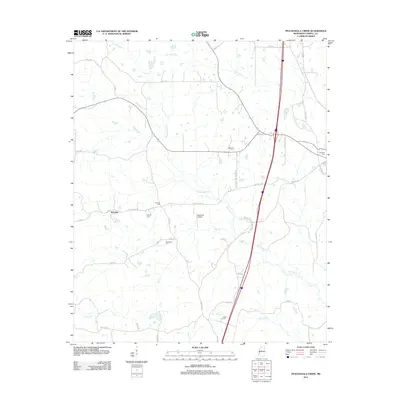
2012 Map of Peachahala Creek
USGS Topo · Published 2012About this map
Peachahala Creek and its many tributaries, including Hurricane Creek and Hagger Creek, define this rural Carroll County landscape in the early 21st century. The map shows a region of dispersed family settlements and winding county roads such as Lively Stone Road and Governor Earl Brewer Road. Genealogists will find a significant concentration of burial sites, including Hopewell Cemetery, Shongola Cemetery, and McEachern Cemetery, which serve as anchors for the local community near the settlement of Wiltshire. The presence of Mitchell's Airport north of Self Creek indicates the integration of small-scale aviation into this traditional agricultural environment, while the path of Old Vaiden Road preserves a connection to the area's older transportation corridors.
Find a feature on this map
41 named features on this map. Tap any name to fly to it.
Don’t see what you’re looking for? This feature index may not catch every label — zoom into the map to look around manually.
Map Details
Editions of this 2012 Peachahala Creek Map
This is the sole edition of this map. No revisions or reprints were ever made.
Other maps of this area

1953 · West Point
USGS Topo · 1:250,000

1958 · West Point
USGS Topo · 1:250,000

1963 · West Point
USGS Topo · 1:250,000

1964 · West
USGS Topo · 1:24,000
1964 · Bowling Green
USGS Topo · 1:24,000

1964 · Hesterville
USGS Topo · 1:24,000

1966 · Winona
USGS Topo · 1:24,000

1966 · Kosciusko
USGS Topo · 1:62,500
1966 · Durant
USGS Topo · 1:62,500
1966 · Vaiden
USGS Topo · 1:24,000